As part of Our Streets Chorlton, Open Data Manchester is creating a monthly environmental data bulletin that showcases some of the local data being collected for the project, including the work done directly by community volunteers.
For the first bulletin, we’ve picked out some of key data points that we think may be relevant and interesting to the residents of Chorlton – with a particular focus on the area around Barlow Hall Primary School on Darley Avenue, as this is where we have an upcoming school-focussed project.
Some highlights include:
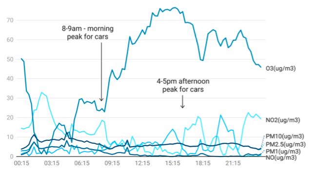
- The average morning peak hour for traffic on Darley Avenue was 08:00-09:00 – the average afternoon peak hour was 15:00-16:00.
- Pollution levels throughout May were recorded as being low both at Darley Avenue and at the junction of Wilbraham Road and Barlow Moor Road – neither location registered higher than a level 3 out of 10 on the Air Quality Index scale.
- The total number of cars recorded on Darley Avenue in July was 22,952, which is down 56% from last month.
While a 56% drop in traffic in one month, from 52,149 cars recorded in April, to just 22,952 in May, is clearly very considerable – we know that Barlow Moor Road, a busy thoroughfare between Chorlton and Manchester, was closed for resurfacing during April – so a large amount of traffic was diverted along Darley Road. We expect the May numbers to be closer to normal.
You can download and explore the full bulletin here.
For the latest on how to get involved with Our Streets Chorlton, including our monthly data chat and Data Champions training, visit ourstreetschorlton.co.uk.